Orumieh
Provincial capital of Western Azarbaijan in an altitude of 1,340 m above sea
level at the extreme northwest of Iran, Orumieh is 946 km away from Tehran by
road. The origins of Orumieh (or Rezaieh from 1930 till 1988), according to some
sources, go back to the civilization of Urartu, in whose language Urmi meant a
fortress. Orumieh, if it is in fact the Urmi of the Urartians, is the legendary
birthplace of Zoroaster and the burial place of one of the Three Magi. The town
nestles amid the foothills of the Turkish frontier, facing a turquoise-colored
lake of inland water. A big market-town, Orumieh has over 650,431 inhabitants of
the most diverse ethnic and religious background: Iranian Turks, Kurds, Chaldean
Christians, Muslims and Catholics.
The largest inland water body in Iran, Lake Orumieh 20 km to the east of the
town, with an area of 6,000 square kilometers and a depth of 6-16 meters, is so
full of salt (though less so than the Dead Sea) that it cannot support any
animal or vegetable life.
Sights to See
-
Friday Mosque
Dating from Seljuk times, 13th century AD (with later restorations), and
located inside bazaar; however, it is thought to incorporate an earlier
structure. The vaulting of the cupola and the spacious prayer hall of the
mosque are of particular architectural interest as regards the construction
of vault, thickness of the foundation, and the solid stone body of the
building.
-
Seh Gonbad
This circular brick tower is a 12th-century AD construction with a crypt in
the lower part and a portal decorated with superb designs.
-
Bazaar
Orumieh has a lively covered bazaar which, though considerably later in date
than the Esfahan bazaar, is built upon the same traditional lines. The domed
vaults have circular openings to provide light, but they also let in rain
and cold so that the tendency today is to cover them with glass.
-
Orumieh Museum
Orumieh Museum with an area of 750 square meters consists of two halls, one
larger than the other. Here you can see archaeological and ethnological
objects and cultural costumes from the earliest prehistoric, pre-Islamic.
And Islamic eras, as well as national arts relics.
Excursions around Orumieh
-
MAKU
When traveling on road from Tabriz to Orumieh, instead of bearing left to
Khoi, if you continue on the road to Bazargan and Turkey, you will come to
Maku (22 km from Turkey) from which several Armenian churches of the
eleventh and twelfth centuries may be visited.
-
Baqcheh Juq Palace-Museum
This historical two-storied palace stands in the center of a spacious garden
covering 11 hectares. The building, dating back from the late Qajar period,
was built by the orders of Eqbal os-Saltaneh Maku`ei, a military commander
of Mozaffar od-Din Shah Qajar.
-
Kara Kelisa
The Armenian Church and Monastery of St Thaddeus, known also as kelisa-ye
Tatavus by the name of St Tadi, and locally called Kara Kelisa (the Black
Church) is situated in desolate, but nowadays easily accessible, country
about 18 km south of Maku.
-
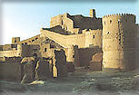
Takht-e Suleiman
The ancient, historical fort Takht-e Suleiman occupies an area of 124,000
square meters and is one of Iran's most important ancient monument,
comprising ruins dating back to the Sassanian, Ashkanian (Arsacid), and
Moghul periods.
Located in a distance of 45 km to the north east of Takab district at an
altitude of 2,400 meters, it consist of a majestic building about 20 meters
high, erected on top of a hill, plus a strong stone battlement.
From the view point of construction and architecture, the monument is highly
remarkable. Adjoining the site are the ruins of Takht-e Bulqais and
Suleiman`s dungeon (Dakhmeh-ye Zendan-e Suleiman).
-
Tappeh Hasanlu
This is a long-lived tell 85 km east of Orumieh and 12 km east of Naqadeh
(itself a historic area whit many relics of ancient civilization of Iran),
excavated by Dyson from 1965 on. Actually, it consists of a 20-meter high
central hill surrounded by a number of 15-meter high peripheral hills.
Historical evidence indicates that the central hill formed the main edifice
and the citadel was a town with temples and administrative parts, the
population of which resided on the encircling hills.