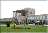
Ahvaz
Capital of Wealthy Khuzestan province in the southwest Iran, and bordering on
cities such as Shushtar and Dezful to the north, Ramhormoz to the east, Shadegan,
Bandar-e Mahshahr, Abadan, and Khorramshahr to the south, Ahvaz is situated on
both banks of Karun River.
Being an oil center, a transportation hub, and an industrial city with
flourishing metallurgical, petrochemical, textile, sugar cane, power generating,
and food-processing industries, it occupies an area of more than 200 square
kilometers. It is terribly hot and humid in spring and summer. Its population
amounts to more than 1,000,000 mainly Shiite Muslims.
Its elevation from the sea level is only 18 meters. The best season for
traveling to Ahvaz and the whole Khuzestan province is from January to late
April.
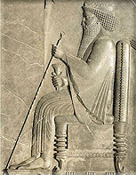
As an ancient city, its name appears in many inscriptions of ancient Iran.
Its original name, according to archaeological evidence is said to have been
Oxin. Achaemenians called it Avaz or Avaja. During the Sassanian (3rd century
AD), Ahvaz was rebuilt by Ardashir I, who named it Hormozd-Ardeshir. In the 4th
century AD, Ahvaz became a seat of bishopric, and a large church was built
there. However, it was renamed to Souq al-Ahvaz following the Arab Conquest. It
was an important trading center with Arab world in the 12th and 13th centuries
but later declined.
During the Qajar period a harbor was built by the order of Nasser od-Din Shah
(during whose reign the town was called Nasseri) not far from the present
location of Ahvaz on the Karun River for trading purposes, and the river was
opened to foreign trade in 1888. Finally, it was called Ahvaz and designated as
the capital of Khuzestan province during the reign of Reza Shah Pahlavi in 1924.
Karun is a 900-km long river that rises in the Zagros Mountains, west Iran,
and flows south to the Arvand (or Satt ol-Arab) on the Iragi border. Since the
construction of Trans-Iranian Railway during World War II the Karun River has
been navigable up to Ahvaz for shallow drift vessels; rapids prevent further
upstream passage except during high water in April and May. Five bridges connect
both parts of the town. Two of these bridges are A) Railway Bridge and, locally
known as Pol-e Felezi; and B) Suspension Bridge, both built by the order of Reza
Shah Pahlavi in 1932 and 1935, respectively.
The discovery of oil nearby in the early 20th century restored the city to
its former importance. The modern part of Ahvaz, the administrative and
industrial center, is on the right bank of the Karun River, but the population
is still concentrated in the old section on the left bank. Ahvaz is linked by
road, rail, and oil pipelines to Tehran and to ports on the Persian Gulf.
During the 8-year Iraq-Iran War and the holy Defense against Iragi
aggression, the city served as major logistic and resistance center. It was
severely attacked and damaged by the enemy during the war.
Good asphalt roads radiate from Ahvaz to all parts of the province, particularly
to Abadan, Andimeshk, Chogha Zanbil, Dezful, Khorramshahr, Shushtar, and Susa.
Sights to See
Excursions around Ahvaz
-
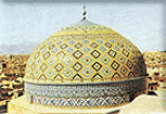
Chogha Zanbil
45 km southeast of Susa. The Elamite Ziggurat was built by Untash-gal, King
of Elam at Dur Untash, a city near Susa, about 1,250 BC, it served as both
temple and tomb.


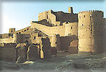
- Dezful
A city 160 km to the north of Ahvaz was built during the reign of Shapur I
(242-271 AD) using Roman soldiers taken prisoner at the battle of Odessa in
260 AD.


Castle the Neighborhood - Dezful

Historic House Syed sadr - Dezful - Iran
- Jam`e Mosque of Dezful
One of the early Islamic monuments, which has been further expanded and
repaired in the 13th and 18th centuries AD.


- Ivan-e Karkheh
The ruins of a splendid brick palace from the Sassanian period (226-652 AD)
in a Distance of 18 km from Dezful.


-
Susa (Shush)
A prehistoric settlement from at least the fort millennium BC, and an
important Elamite city from about the middle of the third millennium. Untash
Gal built Susa as His administrative capital and founded Chogha Zanbil as
his religious center. Later Darius I and Artaxerxes built great palaces
there and became the winter capital of Achaemenians.


Shush Castle