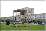
Geography
The Islamic Republic of Iran is bordered to the north by the states of
Armenia, Azerbaijan and Turkmenistan (formerly of the USSR) and the Caspian Sea,
to the east by Afghanistan and Pakistan, to the south by the Sea of Oman and the
Persian Gulf, and to the west by Iraq and Turkey. With an area of some 1,680,000
sq km, just under half the size of India, Iran is the fifth largest country in
Asia.
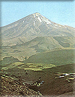
Iran can be described as a vast upland plateau bounded by mountain ranges on
three sides-the Alborz to the north and the Zagros to the south and west-and by
scattered mountains to the east. Most of the rivers in the country drain into
lakes, marshes and inland seas or else evaporate before achieving very much. The
Caspian Sea to the north is the world's largest lake, with an area of some
370,000 sq km. It is a salt lake with about a third of the salt content of
average world seawater, and its surface is on average about 30 meters below
world sea level. The whole of Iran is in an earthquake zone, and there have been
several major tremors this century.
The central Iranian plateau is mostly desert of either sand or compacted silt
and rock, and-except at its fringes where the tableland merges into the Zagros
and the Alborz-most of its mountains are unconnected and of low altitude. Salty
marshes occur in many of the lowest basins.
The settled areas are almost entirely confined to the foothills of mountains.
The two great Iranian deserts, the Dasht-e Kavir (also Kavir-e Bozorg) and the
Dasht-e Lut, occupy a large part of the north-east and east of the central
plain.